thumbnail.png
From the dataset abstract
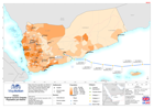
Map shows the population per District in Yemen based on the final results from the census conducted between 2004 - 2012. The storm track of Tropical Cyclone Chapala between the 1st and...
Source: Yemen: Tropical Cyclone Chapala - Population per District
Additional Information
| Field | Value |
|---|---|
| Data last updated | July 28, 2016 |
| Metadata last updated | July 28, 2016 |
| Created | July 28, 2016 |
| Format | PNG |
| License | License not specified |
| Has views | True |
| Id | e77f3b5d-8450-41f9-bc77-7c234e2ba275 |
| On same domain | True |
| Package id | 0a4236ac-14a4-4926-838d-e500d916710f |
| Position | 2 |
| Revision id | c4365226-045d-493a-a698-2cc5c9ac36d7 |
| State | active |
| Url type | upload |