thumbnail.png
From the dataset abstract
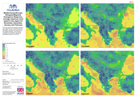
This map shows the average wind speed at each cell for November, December, January and February at 5 km spatial resolution. The data was modelled from ECMWF operational, forecasting...
Additional Information
| Field | Value |
|---|---|
| Data last updated | July 28, 2016 |
| Metadata last updated | July 28, 2016 |
| Created | July 28, 2016 |
| Format | PNG |
| License | License not specified |
| Has views | True |
| Id | 98f2e346-3385-46e9-b86d-5edf93f734a1 |
| On same domain | True |
| Package id | df06d2e4-25c1-4bc6-8369-fba176670213 |
| Position | 2 |
| Revision id | be536fbf-5049-4f58-83d8-8f9c15c30ded |
| State | active |
| Url type | upload |