thumbnail.png
From the dataset abstract
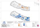
Map shows numbers of collapsed and partially damaged government buildings by district. White areas have zero numbers, grey areas have no data. Map also shows epicentres.
Additional Information
| Field | Value |
|---|---|
| Data last updated | July 28, 2016 |
| Metadata last updated | July 28, 2016 |
| Created | July 28, 2016 |
| Format | PNG |
| License | License not specified |
| Has views | True |
| Id | 212e18d5-9598-45ed-afdc-2551a42312d2 |
| On same domain | True |
| Package id | cb0ae956-9080-4648-9efb-cdd065844b38 |
| Position | 2 |
| Revision id | f0932ff4-b325-4d17-8e57-a5cd698e22b6 |
| State | active |
| Url type | upload |