thumbnail.png
From the dataset abstract
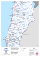
Map shows stream network for the Atacama region derived from elevation data from the Shuttle Topography Radar Mission (produced by HydroSheds)
Source: Chile: Floods - AtacamaStream Network(as of 30 March 2015)
Additional Information
| Field | Value |
|---|---|
| Data last updated | July 28, 2016 |
| Metadata last updated | July 28, 2016 |
| Created | July 28, 2016 |
| Format | PNG |
| License | License not specified |
| Has views | True |
| Id | 736f6141-ad53-4260-9540-8898484fc53c |
| On same domain | True |
| Package id | 4f1d4d25-eee9-4ddd-8862-40d7c971872d |
| Position | 2 |
| Revision id | 1eed149f-7a5b-470c-a5de-063722fef3b9 |
| State | active |
| Url type | upload |