thumbnail.png
From the dataset abstract
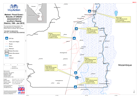
This map shows the Nsanje district. This rapid assessment was undertaken by UNDAC teams on Monday 19th of January.
Source: Malawi: Floods -Results of UNDAC assessement of southern Nsanje District, 19th Jan 2015
Additional Information
| Field | Value |
|---|---|
| Data last updated | July 4, 2016 |
| Metadata last updated | July 4, 2016 |
| Created | July 4, 2016 |
| Format | PNG |
| License | License not specified |
| Has views | True |
| Id | 4ad6cb37-d424-4099-b2ae-c6f34a59e3c3 |
| On same domain | True |
| Package id | d3149797-b7c4-416f-86bd-d784f6ec1f16 |
| Position | 2 |
| Revision id | 4092d490-20a7-4436-b924-ab0e74cf7ca7 |
| State | active |
| Url type | upload |