thumbnail.png
From the dataset abstract
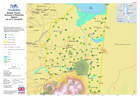
Map shows locations of schools in Phalombe District. Schools have been reported as gathering places for people displaced by recent flooding.
Source: Malawi: Floods - Schools in Phalombe District (as of 17 Jan 2015)
Additional Information
| Field | Value |
|---|---|
| Data last updated | July 4, 2016 |
| Metadata last updated | July 4, 2016 |
| Created | July 4, 2016 |
| Format | PNG |
| License | License not specified |
| Has views | True |
| Id | 9d0b3d0f-2f78-48c9-88ca-832460907e53 |
| On same domain | True |
| Package id | 8338af70-8886-4d01-9acb-899f6d900af5 |
| Position | 2 |
| Revision id | da9e5b5d-7cfc-4d06-bc07-22deaa321a2b |
| State | active |
| Url type | upload |