thumbnail.png
From the dataset abstract
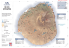
Map shows the extent of lava flows from satellite images on 8 Dec 2014. Evacuated population located in Monte Grande, Achada das Fumas and Mosteiros (UNDAC).
Source: Cape Verde - Fogo Island: Volcanic eruption (as of 9 Dec 2014)
Additional Information
| Field | Value |
|---|---|
| Data last updated | July 4, 2016 |
| Metadata last updated | July 4, 2016 |
| Created | July 4, 2016 |
| Format | PNG |
| License | License not specified |
| Has views | True |
| Id | cc200e26-5c4b-4a5e-bb7a-93455efb3eab |
| On same domain | True |
| Package id | 05aa3b0d-934d-4ff8-9bfd-b056aa80713e |
| Position | 2 |
| Revision id | 722054aa-4cc5-48bf-8d43-a3be9b8d5289 |
| State | active |
| Url type | upload |