thumbnail.png
From the dataset abstract
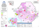
Map shows the location and status of the known Ebola Treatment Units (as of 07/11/2014)Cumulative confirmed case totals are shown for each district, with 7/14/21 day totals labelled Data:...
Additional Information
| Field | Value |
|---|---|
| Data last updated | July 28, 2016 |
| Metadata last updated | July 28, 2016 |
| Created | July 28, 2016 |
| Format | PNG |
| License | License not specified |
| Has views | True |
| Id | 78610596-c8d5-4c16-a7f8-218f4f499a20 |
| On same domain | True |
| Package id | 4714a7b6-14c3-45f8-a10f-ab56daed55ce |
| Position | 2 |
| Revision id | 4bc1b7a4-f525-405d-9d6f-15b68d564bbb |
| State | active |
| Url type | upload |