thumbnail.png
From the dataset abstract
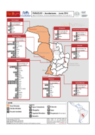
Map represents humanitarian sector presence in the most affected areas (Alto Paraguay, Presidente Hayes (Bajo Chaco), Asuncion, Ñeembucú).
Source: Paraguay: Inundaciones - Mapa de Afectación y Presencia Humanitaria Sectorial al 19 de Junio 2014
Additional Information
| Field | Value |
|---|---|
| Data last updated | July 28, 2016 |
| Metadata last updated | July 28, 2016 |
| Created | July 28, 2016 |
| Format | PNG |
| License | License not specified |
| Has views | True |
| Id | bd442f27-ebca-4c10-9824-3d365567e86c |
| On same domain | True |
| Package id | 42673bad-dbc9-4a29-be94-1ccf61b4577e |
| Position | 2 |
| Revision id | 453cd7d6-9166-46d4-a80d-ac1535a872c2 |
| State | active |
| Url type | upload |