thumbnail.png
From the dataset abstract
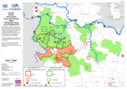
Map shows municipalities, districts and cities where the Government of Serbia are reporting delivery of food and water compared to reports of most seriously affected food locations and...
Source: Serbia: Floods - Government Food and Drinking Water Distribution Areas (as of 25 May 2014)
Additional Information
| Field | Value |
|---|---|
| Data last updated | July 28, 2016 |
| Metadata last updated | July 28, 2016 |
| Created | July 28, 2016 |
| Format | PNG |
| License | License not specified |
| Has views | True |
| Id | f0ce3267-e835-4733-ab03-bbdb33ac8a8f |
| On same domain | True |
| Package id | 61dbda50-86eb-4de1-95c9-87eb48075310 |
| Position | 2 |
| Revision id | 1b89ed45-2e6e-4161-9cb6-a3bf29da8b86 |
| State | active |
| Url type | upload |