thumbnail.png
From the dataset abstract
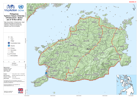
Map shows Bohol. Infrastructure, major transport terminals are shown for reference. Please be advised that datasets may not be complete.
Source: Philippines Typhoon Haiyan (Yolanda) Infrastructure - Bohol (as of 19 Nov-2013)
Additional Information
| Field | Value |
|---|---|
| Data last updated | July 28, 2016 |
| Metadata last updated | July 28, 2016 |
| Created | July 28, 2016 |
| Format | PNG |
| License | License not specified |
| Has views | True |
| Id | 789b2eec-34d0-4154-8444-ef552db48aad |
| On same domain | True |
| Package id | 907cba0c-7271-4bdd-b6a6-4e21c25f1477 |
| Position | 1 |
| Revision id | 1e94c2e5-5fd2-4524-aaba-c936659bf576 |
| State | active |
| Url type | upload |