thumbnail.png
From the dataset abstract
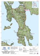
Map shows the province of Leyte. Infrastructure, major transport terminals are shown for reference. Please be advised that datasets may not be complete.
Source: Philippines Typhoon Haiyan (Yolanda) Infrastructure - Leyte (as of 16 Nov-2013)
Additional Information
| Field | Value |
|---|---|
| Data last updated | July 28, 2016 |
| Metadata last updated | July 28, 2016 |
| Created | July 28, 2016 |
| Format | PNG |
| License | License not specified |
| Has views | True |
| Id | 4649e667-089c-4c6a-a2db-d5712a5952a9 |
| On same domain | True |
| Package id | 500e240b-3952-42c6-bdb3-b8dd52f09790 |
| Position | 2 |
| Revision id | 16ac72ff-959d-4a67-aa77-f758bf18ce3d |
| State | active |
| Url type | upload |