thumbnail.png
From the dataset abstract
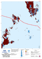
Map shows number of people in evacuation centres by municipality in Palawan and Antique regions.Please be advised that datasets may not be complete.
Source: Philippines Typhoon Haiyan (Yolanda) Evacuation Centres, Palawan and Antique (as of 15-Nov-2013)
Additional Information
| Field | Value |
|---|---|
| Data last updated | July 28, 2016 |
| Metadata last updated | July 28, 2016 |
| Created | July 28, 2016 |
| Format | PNG |
| License | License not specified |
| Has views | True |
| Id | 03263306-a543-4694-8245-85a3a7a8b99a |
| On same domain | True |
| Package id | 8b63a3ec-4040-4707-a7ef-dad867a6dd3a |
| Position | 2 |
| Revision id | d4e844db-2072-4fa1-945d-55526a19ab36 |
| State | active |
| Url type | upload |