thumbnail.png
From the dataset abstract
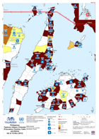
Map shows number of people in evacuation centres by municipality in Bohol and Cebu. Please be advised that datasets may not be complete.
Source: Philippines Typhoon Haiyan (Yolanda) Evacuation Centres, Cebu and Bohol (as of 15-Nov-2013)
Additional Information
| Field | Value |
|---|---|
| Data last updated | July 28, 2016 |
| Metadata last updated | July 28, 2016 |
| Created | July 28, 2016 |
| Format | PNG |
| License | License not specified |
| Has views | True |
| Id | efe91857-45b4-4565-b3a9-d927870e1349 |
| On same domain | True |
| Package id | 495de23e-e193-49f9-b0e6-fa5ee2906bfd |
| Position | 1 |
| Revision id | 0ddf93e5-5ec6-4058-8fba-8f3fea0fd551 |
| State | active |
| Url type | upload |