thumbnail.png
From the dataset abstract
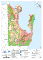
Map shows basic infrastructure and graded buildings damage for Tacloban City and near area. Damage data is derived from satellite imagery and has not been verified on the ground, the date...
Source: Philippines Typhoon Haiyan (Yolanda) Infrastructure - Tacloban City (as of 15-Nov-2013)
Additional Information
| Field | Value |
|---|---|
| Data last updated | July 28, 2016 |
| Metadata last updated | July 28, 2016 |
| Created | July 28, 2016 |
| Format | PNG |
| License | License not specified |
| Has views | True |
| Id | c93df90f-5b53-4f43-82b5-6fb1cb5fcf89 |
| On same domain | True |
| Package id | ab3af9b6-6f83-43a4-ab55-e788ed0a100e |
| Position | 2 |
| Revision id | 8ea3d956-3d1d-4e4d-ac8d-5797034024b8 |
| State | active |
| Url type | upload |