thumbnail.png
From the dataset abstract
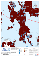
Map shows number of people in evacuation centres by municipality in Leyte. Please be advised that datasets may not be complete.
Source: Philippines Typhoon Haiyan (Yolanda) Evacuation Centres in Leyte (as of 12 Nov 2013)
Additional Information
| Field | Value |
|---|---|
| Data last updated | July 28, 2016 |
| Metadata last updated | July 28, 2016 |
| Created | July 28, 2016 |
| Format | PNG |
| License | License not specified |
| Has views | True |
| Id | 0abe9784-7c16-4f1c-8fdc-c9632d8d2c21 |
| On same domain | True |
| Package id | 5f2b2262-49f7-4e46-ab6b-86e34cd79de0 |
| Position | 2 |
| Revision id | 76c5f59a-2fdc-41b0-adc5-be5563963b46 |
| State | active |
| Url type | upload |