thumbnail.png
From the dataset abstract
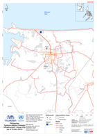
Map shows Roxas City and near area. Roads are shown for reference, little other infrastructure data is available at this time.Please be advised that datasets may not be complete.
Source: Philippines Typhoon Haiyan (Yolanda) Infrastructure - Roxas City (as of 10 Nov 2013)
Additional Information
| Field | Value |
|---|---|
| Data last updated | July 28, 2016 |
| Metadata last updated | July 28, 2016 |
| Created | July 28, 2016 |
| Format | PNG |
| License | License not specified |
| Has views | True |
| Id | 792df01b-bf18-49ea-ad85-a2aad20b0709 |
| On same domain | True |
| Package id | 23b16bd8-e0f1-4cd0-9620-5284be447a50 |
| Position | 2 |
| Revision id | 31a19f29-5406-42f6-99d8-703c742b8de5 |
| State | active |
| Url type | upload |