thumbnail.png
From the dataset abstract
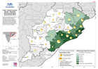
Map shows data for districts in Odisha state, plus one district of Andhra Preadesh. Figures are shown for percentages of district populations as reported by Government (taking the highest...
Source: ndia: Tropical Cyclone Phailin - Reported affected population (as at 28 Oct 2013)
Additional Information
| Field | Value |
|---|---|
| Data last updated | July 28, 2016 |
| Metadata last updated | July 28, 2016 |
| Created | July 28, 2016 |
| Format | PNG |
| License | License not specified |
| Has views | True |
| Id | 29b93c29-26bb-493e-82fd-9293e5e0cfdf |
| On same domain | True |
| Package id | cafc3b99-b21a-46e7-abb9-1e8b0dd58057 |
| Position | 2 |
| Revision id | efa0b0b9-efc9-4ec3-90bd-bc78e1602574 |
| State | active |
| Url type | upload |