thumbnail.png
From the dataset abstract
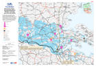
This map shows the general situation overview including the likely area to be flooded as well as number of IDPs in camps on the morning of 1.10.2013. The Camp location are only known by...
Source: EXERCISE: Hurricane Fubar - Nordland/Sydland Shelter overview (as of 01 Oct 2013)
Additional Information
| Field | Value |
|---|---|
| Data last updated | July 28, 2016 |
| Metadata last updated | July 28, 2016 |
| Created | July 28, 2016 |
| Format | PNG |
| License | License not specified |
| Has views | True |
| Id | f573068c-4130-469c-80b6-60aa049873e7 |
| On same domain | True |
| Package id | ea8b52f2-c1cf-4e68-8ee4-2f3172830c39 |
| Position | 2 |
| Revision id | 3fdc27d1-e5ff-400d-80a7-903a52103f5c |
| State | active |
| Url type | upload |