thumbnail.png
From the dataset abstract
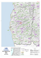
Map of Tartous Governorate showing sub-district boundaries over basemap (includes District and Sub-District names in English with P-Codes)
Additional Information
| Field | Value |
|---|---|
| Data last updated | July 28, 2016 |
| Metadata last updated | July 28, 2016 |
| Created | July 28, 2016 |
| Format | PNG |
| License | License not specified |
| Has views | True |
| Id | 9619e37e-708e-4fd3-9726-454e65fa232a |
| On same domain | True |
| Package id | a254d09e-3906-4ec5-93bc-84024f1c9ba4 |
| Position | 2 |
| Revision id | 55df51d0-2a6e-49ec-8ac7-59220345836e |
| State | active |
| Url type | upload |