thumbnail.png
From the dataset abstract
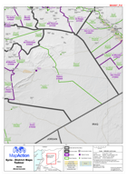
Map of Tadmor District in Homs Governorate, Syria, showing sub-district boundaries over basemap (includes District and Sub-District names in English and Arabic with P-Codes)
Source: Syria - District Maps: Tadmor District in Homs Governorate
Additional Information
| Field | Value |
|---|---|
| Data last updated | July 28, 2016 |
| Metadata last updated | July 28, 2016 |
| Created | July 28, 2016 |
| Format | PNG |
| License | License not specified |
| Has views | True |
| Id | 0b039c97-f502-48fb-a0d9-d86932aa8bfc |
| On same domain | True |
| Package id | aa6fe344-8857-45d8-bb65-812253c2c662 |
| Position | 2 |
| Revision id | 0d375c51-f70a-45ef-b231-a9448b733ec0 |
| State | active |
| Url type | upload |