thumbnail.png
From the dataset abstract
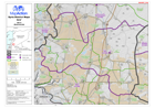
Map of Izra District in Dar'a Governorate, Syria, showing sub-district boundaries over basemap (includes District and Sub-District names in English and Arabic with P-Codes)
Source: Syria - District Maps: Izra District in Dar'a Governorate
Additional Information
| Field | Value |
|---|---|
| Data last updated | July 28, 2016 |
| Metadata last updated | July 28, 2016 |
| Created | July 28, 2016 |
| Format | PNG |
| License | License not specified |
| Has views | True |
| Id | c6cc59c5-82a4-44cc-a131-921c3ccd3d93 |
| On same domain | True |
| Package id | c77093fd-2b64-41a1-b6e7-abe93e37a8bf |
| Position | 2 |
| Revision id | 5c6fa7e0-c364-4871-8bdf-20457784e6cf |
| State | active |
| Url type | upload |