thumbnail.png
From the dataset abstract
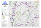
Map of Ariha District in Idleb Governorate, Syria, showing sub-district boundaries over basemap (includes District and Sub-District names in English and Arabic with P-Codes)
Source: Syria - District Maps: Ariha District in Idleb Governorate
Additional Information
| Field | Value |
|---|---|
| Data last updated | July 28, 2016 |
| Metadata last updated | July 28, 2016 |
| Created | July 28, 2016 |
| Format | PNG |
| License | License not specified |
| Has views | True |
| Id | f7d8f5f1-42dd-4772-aff7-d7db6879cd19 |
| On same domain | True |
| Package id | dd72b40f-13a7-4498-879b-b608177be648 |
| Position | 2 |
| Revision id | ce6678f8-8a0b-487d-8ba8-ebcba717f24d |
| State | active |
| Url type | upload |