thumbnail.png
From the dataset abstract
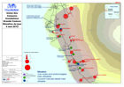
Map showing flood affected population and status of affected transport infrastructure, as of 4 May 2012. [In French]
Source: Union des Comores Inondations Grande Comore Situation du jour 4 mai 2012
Additional Information
| Field | Value |
|---|---|
| Data last updated | July 28, 2016 |
| Metadata last updated | July 28, 2016 |
| Created | July 28, 2016 |
| Format | PNG |
| License | License not specified |
| Has views | True |
| Id | ff54bd1c-c698-4076-be6a-aa21b6e25e1e |
| On same domain | True |
| Package id | 75a99dba-9096-409e-8144-cbdce649788c |
| Position | 2 |
| Revision id | 3317a197-e0fe-474f-a3e7-75e7fbea3a57 |
| State | active |
| Url type | upload |