thumbnail.png
From the dataset abstract
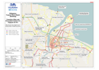
Map shows the city of Cagayan de Oro and the location of Evacuation Centres / Transitory Sites as at 20th January 2012
Additional Information
| Field | Value |
|---|---|
| Data last updated | July 28, 2016 |
| Metadata last updated | July 28, 2016 |
| Created | July 28, 2016 |
| Format | PNG |
| License | License not specified |
| Has views | True |
| Id | fd0c5c39-77fb-414d-8dfd-5a17d32e9d3d |
| On same domain | True |
| Package id | 6baeca78-07be-4779-a3a1-fff49c80d00a |
| Position | 2 |
| Revision id | a0a9551e-ddec-44f9-a26a-3390632aa655 |
| State | active |
| Url type | upload |