thumbnail.png
From the dataset abstract
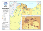
Map shows Barangays shaded by population density for each Barangay, based on the 2007 census and the location of Evacuation Centres / Transitory Sites. Each Barangay is labelled with the...
Additional Information
| Field | Value |
|---|---|
| Data last updated | July 28, 2016 |
| Metadata last updated | July 28, 2016 |
| Created | July 28, 2016 |
| Format | PNG |
| License | License not specified |
| Has views | True |
| Id | a6660a2d-6a98-4158-ba72-7f8d97f89597 |
| On same domain | True |
| Package id | 30fa0194-3b8b-4d12-a2c7-4f25d6c130f3 |
| Position | 2 |
| Revision id | 80f33a63-0711-4db1-964f-4124e211b2cb |
| State | active |
| Url type | upload |