thumbnail.png
From the dataset abstract
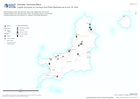
Map displaying roads, ferry terminal, ferry route, settlements and critical building infrastructure that are known. Note: No granular data is currently held showing warehouses and...
Source: Logistic structures on Carriacou and Petite Martinique as at July 19, 2024
Additional Information
| Field | Value |
|---|---|
| Data last updated | July 19, 2024 |
| Metadata last updated | July 19, 2024 |
| Created | July 19, 2024 |
| Format | PNG |
| License | License not specified |
| Has views | True |
| Id | 23073caf-0746-4d55-905f-921fd11d0c21 |
| Mimetype | image/png |
| On same domain | True |
| Package id | 27daa4a2-f484-40bb-bae3-5eb1bbefa06f |
| Position | 2 |
| Revision id | 1224f0e9-50dd-428e-ac2c-302856fc1a40 |
| Size | 9.8 KiB |
| State | active |
| Url type | upload |