thumbnail.png
From the dataset abstract
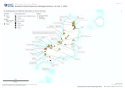
Map displaying roads and settlements with locations in Carriacou that have been reported with observations of damage to buildings/critical infrastructure.
Source: Buildings/Critical Infrastructure Damage Carriacou as at July 18, 2024
Additional Information
| Field | Value |
|---|---|
| Data last updated | July 18, 2024 |
| Metadata last updated | July 18, 2024 |
| Created | July 18, 2024 |
| Format | PNG |
| License | License not specified |
| Has views | True |
| Id | ba747a8b-5ba4-46bb-b023-87134f1a7591 |
| Mimetype | image/png |
| On same domain | True |
| Package id | c7f3f099-b284-4894-9131-679ac97ee687 |
| Position | 2 |
| Revision id | 101369a5-a2d8-4a98-bb06-4f888835d38e |
| Size | 11.4 KiB |
| State | active |
| Url type | upload |