thumbnail.png
From the dataset abstract
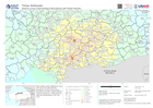
Map showing major settlements (cities and towns) and administrative boundaries at district level (whose boundaries are within Shake Intensity: "Strong" and above). Shake Intensity data...
Source: Districts (Level 2 Administrative Boundaries) with Shake Intensity
Additional Information
| Field | Value |
|---|---|
| Data last updated | February 9, 2023 |
| Metadata last updated | February 9, 2023 |
| Created | February 9, 2023 |
| Format | PNG |
| License | License not specified |
| Has views | True |
| Id | a98e3e67-03b4-4f6d-b98d-6b535f121847 |
| Mimetype | image/png |
| On same domain | True |
| Package id | 91e5e6fd-9f8a-426a-9a9e-1972f45f613c |
| Position | 2 |
| Revision id | 3e780387-81bd-4ecd-af89-32568bf6963c |
| Size | 24.9 KiB |
| State | active |
| Url type | upload |