thumbnail.png
From the dataset abstract
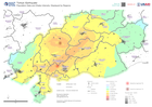
This map shows the region extent of the earthquake that happened in Turkey on the 6th of February. The map displays the population density in 1 kilometer grids and shake intensity....
Source: Population Data and Shake Intensity: Displayed by Regions
Additional Information
| Field | Value |
|---|---|
| Data last updated | February 8, 2023 |
| Metadata last updated | February 8, 2023 |
| Created | February 8, 2023 |
| Format | PNG |
| License | License not specified |
| Has views | True |
| Id | 37150154-85ca-4b4d-be0d-42fab9eff1fe |
| Mimetype | image/png |
| On same domain | True |
| Package id | 66bb367c-000e-432d-aa93-76f26051a193 |
| Position | 2 |
| Revision id | 626192ff-39fb-4b4d-ac24-178e4d266c06 |
| Size | 22 KiB |
| State | active |
| Url type | upload |