thumbnail.png
From the dataset abstract
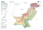
Country overview map showing main settlements, transport links, elevation, water features and administrative boundaries
Source: Country Overview
Additional Information
| Field | Value |
|---|---|
| Data last updated | September 2, 2022 |
| Metadata last updated | September 2, 2022 |
| Created | September 2, 2022 |
| Format | PNG |
| License | License not specified |
| Has views | True |
| Id | 83788358-f685-4031-bf39-e2a8f30a6d29 |
| Mimetype | image/png |
| On same domain | True |
| Package id | 75644101-4004-4ef7-823a-7a8e05296cee |
| Position | 2 |
| Revision id | e9c1be0a-abaf-4ea1-88d4-2cb3180b7519 |
| Size | 16.3 KiB |
| State | active |
| Url type | upload |