thumbnail.png
From the dataset abstract
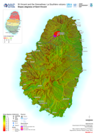
Map shows the slopes of Saint Vincent and the extent of the ash from the La Soufrière eruptions.
Additional Information
| Field | Value |
|---|---|
| Data last updated | May 7, 2021 |
| Metadata last updated | May 7, 2021 |
| Created | May 7, 2021 |
| Format | PNG |
| License | License not specified |
| Has views | True |
| Id | 0d5a9d9d-04e3-4126-a1a9-b5041e1d3504 |
| Mimetype | image/png |
| On same domain | True |
| Package id | 702adc20-ae12-4b93-93b8-ac12300cab61 |
| Position | 2 |
| Revision id | 61537f2b-ab01-492d-b7a8-c56f5971b8fe |
| Size | 33.5 KiB |
| State | active |
| Url type | upload |