thumbnail.png
From the dataset abstract
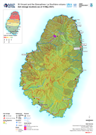
Map shows the slopes of Saint Vincent and the location of known ash storage.
Additional Information
| Field | Value |
|---|---|
| Data last updated | May 21, 2021 |
| Metadata last updated | May 21, 2021 |
| Created | May 21, 2021 |
| Format | PNG |
| License | License not specified |
| Has views | True |
| Id | 5be9fb75-9d3e-4b88-a77c-eb2ff2a87c9e |
| Mimetype | image/png |
| On same domain | True |
| Package id | 93bf0acc-3df0-4ed3-b75f-0123403b059a |
| Position | 2 |
| Revision id | 93f8b88f-62e6-4b43-a31f-8f8e2998cc7c |
| Size | 47.4 KiB |
| State | active |
| Url type | upload |