thumbnail.png
From the dataset abstract
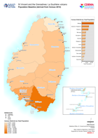
Map shows population by census districts. This is on the basis of information obtained from the 2012 Population and Housing Censuses.
Additional Information
| Field | Value |
|---|---|
| Data last updated | April 18, 2021 |
| Metadata last updated | April 18, 2021 |
| Created | April 18, 2021 |
| Format | PNG |
| License | License not specified |
| Has views | True |
| Id | 2fc07cf1-b21e-421e-b4d3-c005e8e0bc4b |
| Mimetype | image/png |
| On same domain | True |
| Package id | e3869b3b-af98-4b23-a79f-041fa242bb4f |
| Position | 4 |
| Revision id | 10d9f666-8778-40a6-90cf-b8ad5adeaf72 |
| Size | 21.6 KiB |
| State | active |
| Url type | upload |