MA010 - PopulationDistribution_v02-thumbnail.png
From the dataset abstract
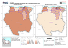
Map shows the population distribution across the Districts of Suriname as well as the population density per km2
Source: Population Distribution and Density map of Suriname at District level
Additional Information
| Field | Value |
|---|---|
| Data last updated | June 24, 2021 |
| Metadata last updated | June 24, 2021 |
| Created | June 24, 2021 |
| Format | PNG |
| License | License not specified |
| Has views | True |
| Id | 9df24a2a-ce00-4828-abbe-3c13e189c911 |
| Mimetype | image/png |
| On same domain | True |
| Package id | c3395e31-55c7-4a7f-bd6c-0386fe61e918 |
| Position | 3 |
| Revision id | aeb51f96-997b-4d5e-93e6-6fc6290820c6 |
| Size | 16.9 KiB |
| State | active |
| Url type | upload |