thumbnail.png
From the dataset abstract
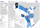
The map provides an overview of drought conditions as reported through household surveys from 6-15th November 2021. The bar charts provide the percentage reported responses on conflict...
Source: ASAL Humanitarian Network Response - Assessment of Drought Impact - Conflict
Additional Information
| Field | Value |
|---|---|
| Data last updated | February 19, 2022 |
| Metadata last updated | February 19, 2022 |
| Created | February 19, 2022 |
| Format | PNG |
| License | License not specified |
| Has views | True |
| Id | 865230e4-4b5a-4f0f-a0af-3446abc01542 |
| Mimetype | image/png |
| On same domain | True |
| Package id | 5a430f69-b0d9-4836-ab40-7e887d2190dd |
| Position | 2 |
| Revision id | e447989b-21aa-4d63-92d5-40fb60a73c8c |
| Size | 16.8 KiB |
| State | active |
| Url type | upload |