thumbnail.png
From the dataset abstract
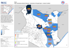
The map provides an overview of drought conditions as reported through household surveys from 6-15th November 2021. The bar charts provide the percentage reported responses on drought...
Source: ASAL Humanitarian Network Response - Assessment of Drought Impact - Livestock Condition
Additional Information
| Field | Value |
|---|---|
| Data last updated | February 19, 2022 |
| Metadata last updated | February 19, 2022 |
| Created | February 19, 2022 |
| Format | PNG |
| License | License not specified |
| Has views | True |
| Id | dbacc071-6306-4113-a8b2-0fbea779c538 |
| Mimetype | image/png |
| On same domain | True |
| Package id | c37d2f7b-2a52-42d5-bab3-403065a568a5 |
| Position | 2 |
| Revision id | 960aaabc-050f-4029-b91d-6650265c809e |
| Size | 16.6 KiB |
| State | active |
| Url type | upload |