thumbnail.png
From the dataset abstract
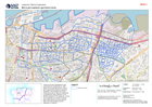
These zones were developed to help coordinate and collaborate on relief efforts at the operational level. Level 3 Administrative boundaries in Lebanon ‘Cadasters’ were divided into Zones....
Additional Information
| Field | Value |
|---|---|
| Data last updated | August 12, 2020 |
| Metadata last updated | August 12, 2020 |
| Created | August 12, 2020 |
| Format | PNG |
| License | License not specified |
| Has views | True |
| Id | 195792cb-3faf-4df9-b4ab-b3b6c2a296d9 |
| Mimetype | image/png |
| On same domain | True |
| Package id | b966b208-9f74-4c68-8323-871e6d1d3614 |
| Position | 2 |
| Revision id | 416ed0cb-fd9b-4a00-8ed8-96132a007004 |
| Size | 29.8 KiB |
| State | active |
| Url type | upload |