thumbnail.png
From the dataset abstract
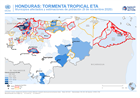
This map shows the affected administration level 2 municipalities for Honduras, with projected population 2020 (INE) and the level of severity (critical or high) for affected...
Source: Honduras: Municipios afectados y estimaciones de población (9 de noviembre 2020)
Additional Information
| Field | Value |
|---|---|
| Data last updated | November 10, 2020 |
| Metadata last updated | November 10, 2020 |
| Created | November 10, 2020 |
| Format | PNG |
| License | License not specified |
| Has views | True |
| Id | 84d76fb1-dadf-47b2-8b07-c9b7635e85be |
| Mimetype | image/png |
| On same domain | True |
| Package id | c52b0288-96d5-4ef8-b2f0-6d4d54efa432 |
| Position | 2 |
| Revision id | b1966b64-0e8c-4aa3-8d14-cadc9b8c4085 |
| Size | 17.6 KiB |
| State | active |
| Url type | upload |