thumbnail.png
From the dataset abstract
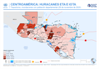
This map shows the storm tracks and flood extents for hurricane Eta and Iota, with baseline administrative 1 level departmental population figures across the affected region (Nicaragua,...
Additional Information
| Field | Value |
|---|---|
| Data last updated | November 27, 2020 |
| Metadata last updated | November 27, 2020 |
| Created | November 27, 2020 |
| Format | PNG |
| License | License not specified |
| Has views | True |
| Id | 8d5456b9-d0ec-4ac9-aa7b-5cb8550de289 |
| Mimetype | image/png |
| On same domain | True |
| Package id | f065c0d7-0e6d-4aa8-a25d-2178bcbe2980 |
| Position | 2 |
| Revision id | 689d7460-909b-412d-bafb-62ddaed2e9fd |
| Size | 17.3 KiB |
| State | active |
| Url type | upload |