thumbnail.png
From the dataset abstract
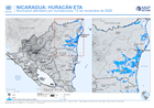
This map shows the administration level 2 municipalities for Nicaragua. Named municipalities are those affected by flood extents, derived from satellite imagery (6-9 November 2020).
Source: NICARAGUA: HURACÁN ETA - Municipios afectados por inundaciones: 13 de noviembre de 2020
Additional Information
| Field | Value |
|---|---|
| Data last updated | December 7, 2020 |
| Metadata last updated | December 7, 2020 |
| Created | December 7, 2020 |
| Format | PNG |
| License | License not specified |
| Has views | True |
| Id | ad411e83-fa9a-4402-8112-502a19ee73f9 |
| Mimetype | image/png |
| On same domain | True |
| Package id | 2909961e-1607-40e8-9f73-dd66af042084 |
| Position | 2 |
| Revision id | 2ff0e9d8-cab5-4735-bc22-3e9b4e77856a |
| Size | 23.9 KiB |
| State | active |
| Url type | upload |