thumbnail.png
From the dataset abstract
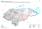
Map shows evacuated persons and number of evacuation centres per Municipality (as at 14th Nov 2020)
Source: Honduras: Evacuated Persons and number of Evacuation Centres per Municipality (as at 17th Nov 2020)
Additional Information
| Field | Value |
|---|---|
| Data last updated | November 18, 2020 |
| Metadata last updated | November 18, 2020 |
| Created | November 18, 2020 |
| Format | PNG |
| License | License not specified |
| Has views | True |
| Id | e154b82a-64f7-4b57-acaf-84a313d49094 |
| Mimetype | image/png |
| On same domain | True |
| Package id | f2375751-aa7a-4402-a200-03d8b00beb3a |
| Position | 2 |
| Revision id | ef023e17-c34a-4698-9c59-c8cbe6828a0e |
| Size | 14.6 KiB |
| State | active |
| Url type | upload |