thumbnail.png
From the dataset abstract
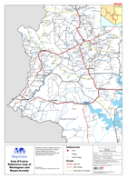
Reference map for UNDAC mission to Côte d’Ivoire in April 2011. Shows western Regions focusing on Montagnes and Moyen-Cavally and adjacent districts of Liberia.
Source: Côte d’Ivoire: Reference map of Montagnes and Moyen-Cavally Regions
Additional Information
| Field | Value |
|---|---|
| Data last updated | July 28, 2016 |
| Metadata last updated | July 28, 2016 |
| Created | July 28, 2016 |
| Format | PNG |
| License | License not specified |
| Has views | True |
| Id | da71f096-b584-4424-9e07-a31f898f0cf5 |
| On same domain | True |
| Package id | bb9746cd-6506-4b3d-ba1c-88622a839b3c |
| Position | 2 |
| Revision id | 929fff57-62bb-408e-8a91-ab85a09e80c7 |
| State | active |
| Url type | upload |