thumbnail.png
From the dataset abstract
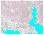
Detailed topographic mapping, scale 1:25,000. Each sheet covers approximately 11 x 9 km. For use only in disaster relief activities, by kind permission of Geospatial Information Authority...
Source: Japan Earthquake: 1:25,000 Topographic Sheet 584145 Ohfunato
Additional Information
| Field | Value |
|---|---|
| Data last updated | July 28, 2016 |
| Metadata last updated | July 28, 2016 |
| Created | July 28, 2016 |
| Format | PNG |
| License | License not specified |
| Has views | True |
| Id | bf9291f4-38bd-422f-a8bd-5a4d8ef11451 |
| On same domain | True |
| Package id | 7df4054a-cf34-4276-9c4a-f8cae2fd3788 |
| Position | 2 |
| Revision id | 7430fe78-440c-4e07-aa33-ba32d75e8350 |
| State | active |
| Url type | upload |