thumbnail.png
From the dataset abstract
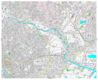
Detailed topographic mapping, scale 1:25,000. Each sheet covers approximately 11 x 9 km. For use only in disaster relief activities, by kind permission of Geospatial Information Authority...
Source: Japan Earthquake: 1:25,000 Topographic Sheet 574037 North East Sendai
Additional Information
| Field | Value |
|---|---|
| Data last updated | July 28, 2016 |
| Metadata last updated | July 28, 2016 |
| Created | July 28, 2016 |
| Format | PNG |
| License | License not specified |
| Has views | True |
| Id | eefd66d1-f415-4273-bd9f-4b50c370f74d |
| On same domain | True |
| Package id | e101321f-52e5-4e94-a2a7-bd6a0dcd2d31 |
| Position | 2 |
| Revision id | 1280fcce-c332-4a7b-9a52-5640eb7dd96b |
| State | active |
| Url type | upload |