thumbnail.png
From the dataset abstract
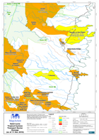
Map shows the location of Transport Sector Damage throughout the island. Also shown are the Ministry of Communications, Works, Transport & Public Utilities Map Zones along with road,...
Source: Saint Lucia Tropical Cyclone Transport Sector Damage (as of 11 Nov 2010) - Map MA016F
Additional Information
| Field | Value |
|---|---|
| Data last updated | July 28, 2016 |
| Metadata last updated | July 28, 2016 |
| Created | July 28, 2016 |
| Format | PNG |
| License | License not specified |
| Has views | True |
| Id | a3ddaf7a-dade-4e21-9268-03346ae1ebc6 |
| On same domain | True |
| Package id | d04a9f62-ea1e-40da-b625-ecf76021dd5c |
| Position | 2 |
| Revision id | de42d4b8-03e4-4f6f-8e17-829251bba9f4 |
| State | active |
| Url type | upload |