thumbnail.png
From the dataset abstract
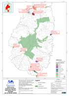
Map shows the location of education buildings with reported damage. Also shown are the quarter boundaries, the national forest reserve, roads and the settlements highlighted that have...
Source: Saint Lucia Tropical Cyclone Education Sector Damage (as of 08 Nov 2010)
Additional Information
| Field | Value |
|---|---|
| Data last updated | July 28, 2016 |
| Metadata last updated | July 28, 2016 |
| Created | July 28, 2016 |
| Format | PNG |
| License | License not specified |
| Has views | True |
| Id | ec7f71ad-a50d-434e-9137-cbbecdf90034 |
| On same domain | True |
| Package id | 668fbaa3-24d4-4d4e-bc92-e72e61632c8e |
| Position | 2 |
| Revision id | 34d7feb9-70d0-4d3c-bede-aaf03a61c954 |
| State | active |
| Url type | upload |