thumbnail.png
From the dataset abstract
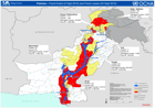
Shows the extent of the flood (2nd Sept 2010) and the numbers of deaths, injured persons, damaged houses and affected population by Province (3rd Sept 2010).
Additional Information
| Field | Value |
|---|---|
| Data last updated | July 28, 2016 |
| Metadata last updated | July 28, 2016 |
| Created | July 28, 2016 |
| Format | PNG |
| License | License not specified |
| Has views | True |
| Id | dac46781-b033-421f-9964-66461efb846e |
| On same domain | True |
| Package id | a4451b99-87f0-48ed-9157-f69cf7a6fdbf |
| Position | 2 |
| Revision id | 93a1d3c6-76bf-4b6d-9ee6-e72801150623 |
| State | active |
| Url type | upload |