thumbnail.png
From the dataset abstract
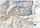
The map is showing the affected areas and the wave progression due to a lake outburst and flooded area.This is expected to follow the landslide that occured on January 4th and which is...
Source: Pakistan - Hunza: Lake Outburst Scenario Map Displaying Flooded Areas. Area 1. T+12.
Additional Information
| Field | Value |
|---|---|
| Data last updated | July 28, 2016 |
| Metadata last updated | July 28, 2016 |
| Created | July 28, 2016 |
| Format | PNG |
| License | License not specified |
| Has views | True |
| Id | 7fdbcce7-720f-43bb-b7a9-72611e0283c0 |
| On same domain | True |
| Package id | 90f2d3b9-f3a6-4ed7-9bb2-428f0011ebd9 |
| Position | 3 |
| Revision id | 677a7ebf-bb97-42c4-826c-195b2a95ae39 |
| State | active |
| Url type | upload |