thumbnail.png
From the dataset abstract
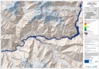
The map is showing the affected areas and the wave progression due to a lake outburst and flooded area.This is expected to follow the landslide that occured on January 4th and which is...
Source: Pakistan - Hunza: Lake Outburst Scenario Map Displaying Flooded Areas. Area 1. T+30.
Additional Information
| Field | Value |
|---|---|
| Data last updated | July 28, 2016 |
| Metadata last updated | July 28, 2016 |
| Created | July 28, 2016 |
| Format | PNG |
| License | License not specified |
| Has views | True |
| Id | bfeaf05c-9ca6-48ac-964a-1bca32837017 |
| On same domain | True |
| Package id | 63870d0e-a8f9-4eb3-8829-01207a19bcb6 |
| Position | 3 |
| Revision id | 56d91e9c-5abf-4725-8a0e-786f4636b975 |
| State | active |
| Url type | upload |